Haleakala Cycle to The Sun
WMC Team
BICYCLE RIDING "UP" HALEAKALA
The Photographs here are from Tom Coat of his lovely wife Ellen Turkel on her memorial ride. I think we can all agree what a fantastic achievement and tribute to her late friend. Thanks for the wonderful Photos Tom!
Aloha. Now that you have decided to tackle the climb up Mt. Haleakala, here are a few tips that might prove to be helpful.
I will attempt to make your ride to the summit a little less daunting. The summit of Haleakala is 10,023 ft above sea level. The official ride route covers just a little longer than 36 miles beginning in the towne of Paia (Baldwin avenue and Hana hwy).

Ellen dipping her toe into the Pacific Ocean early in the morning before the ride on 7/31/2014.
The route is fully paved but not always lending to wide enough roadways to have bicycle lanes. Often you only have a few inches from the far right white lane stripe to the dirt. The road surface varies from Perfect to sections that are mildly rough. Special tires are not needed to get past the rough sections.
Timing of your ride is very important for two reasons. During weekdays (holidays not included) there are a number of private schools along the first 6.5 miles of Baldwin avenue and the next 1.5 miles of Olinda rd. Both of these roads have little or no shoulder for their entirety. Most of the schools begin between 7:30am and 8:00am. This creates a higher level of traffic. Not to pick on parents (only) taking their children to school, but I have personally witnessed some less than courteous driving racing to get little "Sally and Jamie" to school ON TIME.

Morning in the beach town of Paia. An early start is recommended for the ride.
It takes me about 45 minutes to travel this first 8 miles riding at a modest pace. SO, you want to start early enough to be off this section by the Mommy and Daddy driving(racing) time. My suggestion is always sunrise. Summer is about 5:30am and winter is as late as 7:00am. Weather always plays a factor in how early daylight happens on the North Shore. Morning clouds and rain will darken the skies. Check the weather the night before you ride. NOAA.gov works well, or you can check the links below.
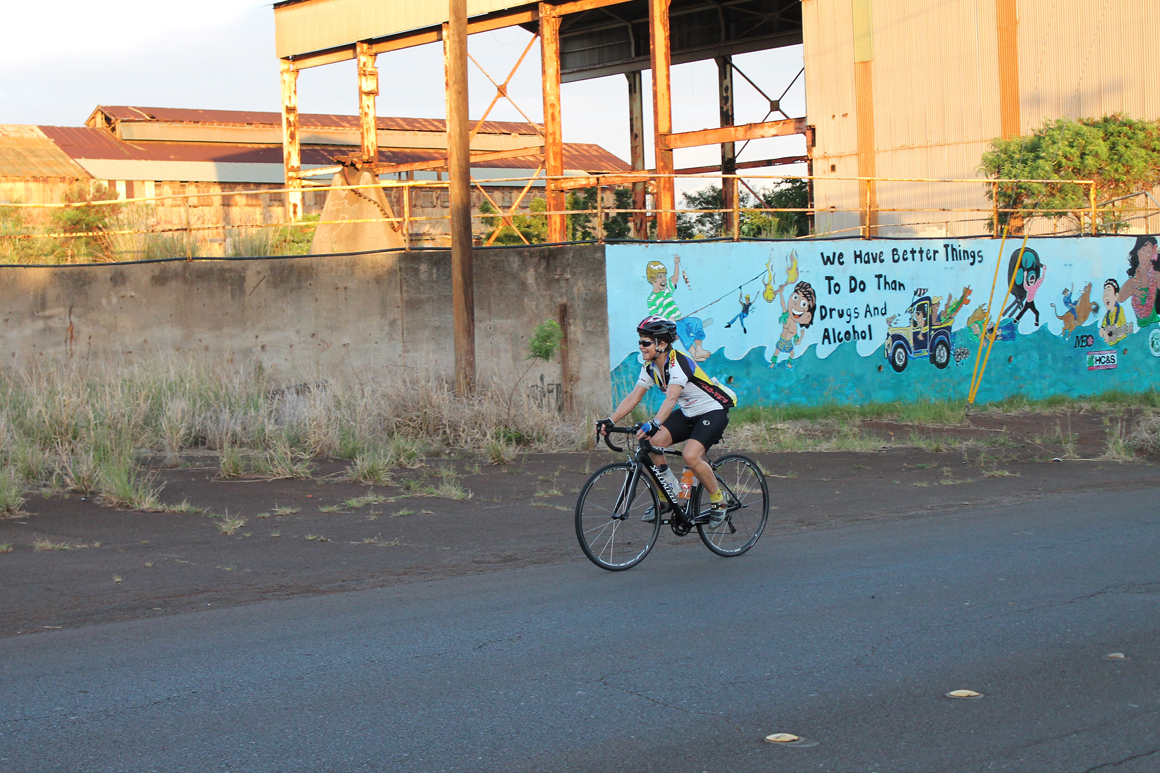
Ellen rides past the old sugar mill at Paia. Even here, the grade was about 4-5 percent.
Speaking about weather, this would be the second reason to get an early start to your Crater Climb. As a general rule of thumb , the temperature at the top of Haleakala is about 30 degrees Fahrenheitcolder than the temp in the towne of Paia. Plenty of people get to the top of Haleakala to witness the beautiful sunrise. The sun rises from the ocean and the clouds to give viewers on a clear morning spectacular views, full of color and rainbows.
Did I say clouds? Sure did. Well, as the morning warms, those clouds usually head west and envelop Mt. Haleakala. You may look at the top of the crater and see how wonderful and clear it looks at sunrise. It takes a few hours for those ocean clouds to make their way onto the mountain. Not every day is like this though, If you get a fully clear day to the top, consider yourself fortunate. I have ridden to the top in everything except snow. A few years ago we did have a few days when the crater was closed due to accumulated snow above the Ranger station (7500ft).
Generally you can expect a cloud and rain line to begin at 5000-6000ft. 6000ft is about 21miles into your ride. This cloud and rain line seems to form about 9:30am, give or take a half hour. Not everyday is like this but in my 23 years of riding Haleakala, most days that rain and cloud line is there mid morning. You tend to rise above this cloud after you pass the Ranger station (7500ft). Unfortunately you might be wet and cold with another 12 miles to ride. I like to be diligent and leave Paia at sunrise and get past the ranger station before that cloud and rain line appears.
I also don't like to take a ton of extra clothing(weight). I weigh quite enough even without my winter cycling wardrobe. You will find out later about my philosophy on why not to take lots of clothes.
What to take for your Haleakala Climb?
A well functioning Road Bicycle with a set of gears that will aid you on your task. At WMC we supply bikes that have a 50t/34t set of front rings and a cog set that has a range of 11t/34t. Otherwise very low gears. Along the route you will encounter less than five places you can actually coast without stopping. This means you are on pedal pressure for most of the 36 miles. Not everyone will need such low gearing. But don't get caught not having some bail out gears to give those aching legs a break.
Good stiff soled bike shoes are a must. Running shoes will make your feet ache before you get to Makawao. I have heard stories from many rental customers who have tried the running shoes with toe straps and cages. They wished they would have used proper riding shoes and clipless pedals. Warm clothing is up to you. If I plan to actually ride back down because I have friends in town and they are amendment about the descent, I take a 30 gallon trash bag with precut arm holes and head hole to use as a wind block. I put it under my "wet" jersey to block the chilling wind. I have made this descent where my body was so cold, I could not control my handlebars. Shaking so violently that I thought I was going to crash. Remember, You just climbed 10,000ft in 36 miles. You probably didn't bring enough food(added weight) to keep you from becoming hypoglycemic. A 30 gallon trash bag is the smallest and lightest wind breaker I have ever found.
Now, the real man's way to do the descent. Ride around the lower summit parking lot and find some visitors who have room in their car or van for you and your bike(make sure they're not the axe-murderer looking types, what ever that looks like these days) and ask if you could get a ride down to at least Kula where it's much warmer. Lots of folks who are in that parking lot passed you on the way up; they probably think you're "NUTS" for climbing Haleakala and would love to hear your story. The best thing to have for your ride is a "SAG VEHICLE" to feed you, have extra clothing and to give you a ride down in case of any bio-mechanical shortcomings.
If the "Sag Vehicle" was not obtainable(usually the case being unable to find a driver silly enough to follow you to the top at 8mph for 4-5hrs). Remember, food and water are your friend. Bring what you are used to. No experimenting with "Local cuisine" wrapped in a baggie. Last water stop is the ranger station at 7500ft. You have 12 miles to get to the top. I do suggest an electrolyte drink or supplement(what works for you only). Maui is quite humid, even heading up the crater. I carry minimal bike spares; a couple of tubes (lower section has more traffic and that is where the most flats occur). Above Kula lodge(13 miles into the ride) the road is much cleaner. Something to inflate tires and the usual tools to make minor repairs; not that you will need them, BECAUSE you are riding a Quality bike suited to this task. That would be the minimum for a typical ascent.
OH, a really important thing to bring is a credit card. Without that , you are NOT getting into the park. And YES, As of Jan 1st 2020 that is a $15.00 charge for EACH cyclist in your group. And NO, they do not accept cash anymore. Charge Card ONLY! Go figure. A van with a family of 15 pays just $30.00 to get into the park. 15 riders on bikes have to pony up $225.00 to be eco friendly to get to the top of the crater. Such Logic.
Now for the actual ride. The official Cycle to the Sun start is on the bypass road that is just next to the first parking lot on the west side of Paia. Head east up the bypass road to Baldwin ave and take a right. The next 6 plus miles will be on Baldwin ave up to the Stop sign at Makawao ave in the town of Makawao. There is little or no shoulder all the way up Baldwin ave. This is a gradual climb up to the town of Makawao. Take in the views. Just spectacular on both sides of the road. You'll see the summit right in front of you. Enjoy this section, It is really mellow.
Just prior to the town of Makawao is a Veterans cemetery. If you are not too early, there are restroom facilities open to the public. After the cemetery you will enter the town of Makawao. Food and snacks are readily available. The Makawao general store on the left is awesome. Great coffee. You have climbed about 1700ft.
At the 4-way stop sign at Makawao ave, you will go straight. Yep, that hill in front of you is steep. I think I saw my Garmin reading 16%. OUCH!!!. Just suck it up , it is less than 1/4 mile. Baldwin Ave will now turn into Olinda rd. after the 4-way stop sign at Makawao Ave. Keep heading up Olinda rd. for about another 3/4 mile. On your left there will be Makawao Rodeo and on the right you will see three(3) white pillars. This is the entrance to Seabury Hall School. About 200 yards past the school is Hanamu rd. Do NOT miss this right turn. If you do, you will climb another 1800ft to a dead end.

The infamous Arena roping sign. If you miss a turn here, you do an extra hour of climbing.
Again , OUCH!!!! once you make this right , you will actually get to COAST, Not log but it still feels wonderful. In about a mile you will come to a fork in the road. This is Kealaloa rd. Stay to the LEFT and follow the road up into the eucalyptus trees. The road winds uphill for about a mile to Haleakala hwy. Just before the hwy on the left is a dog training center. Be careful coming up to the hwy, It's a very steep uphill and blind intersection. Stay to the left of the little traffic triangle that separates the two roads. It is pretty obvious which way to go. UP. Seriously, this intersection can be tricky. Be aware and careful. You have climbed 2000 ft.
I love the next 5 miles to the town of Kula. You are on Haleakala hwy. The next 5 miles wind through some of the most beautiful pastures on Maui. If it is the right time of the year, the Jacaranda (purple) trees will be in bloom. Just awesome. Once you get to Kula, there are two places for restrooms and food. The Kula lodge is at mile marker 5.5 and right next door is a food and art market. You have about a mile to your next turn. You have now climbed about 3300ft.
A mile past Kula lodge you will be making a left turn. There is a large sign that indicates Crater rd. and Haleakala summit(LEFT). You are now gonna feel the climb getting serious. For the next three miles you will be riding through the neighborhood of upper Kula. Just beautiful. Your next bit of food and rest will be the Lavender Coffee stand. It will be on your left next to Skyline Zipline Adventure tours.

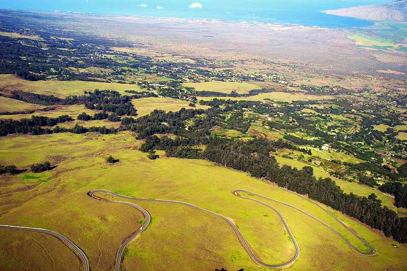
Just after the Zipline, this is the start of the switch backs.
Great coffee and snacks. They open at 6:30am. Great place to stop for a HOT coffee on your way back down. About a mile past the coffee stop you will pass a stand of very old and tall eucalyptus trees. This is where the climb gets real serious.
You will be out in the open, exposed to what ever weather is on hand for the day. You will also encounter the real switchbacks of Haleakala. Some of the turns have grades of 11% plus. Short but punishing. Mahalo to the Cycle to the Sun organizers. They have messages along the race route painted on the pavement. Some indicate the elevation and the one I most like, reminds me to "breathe".

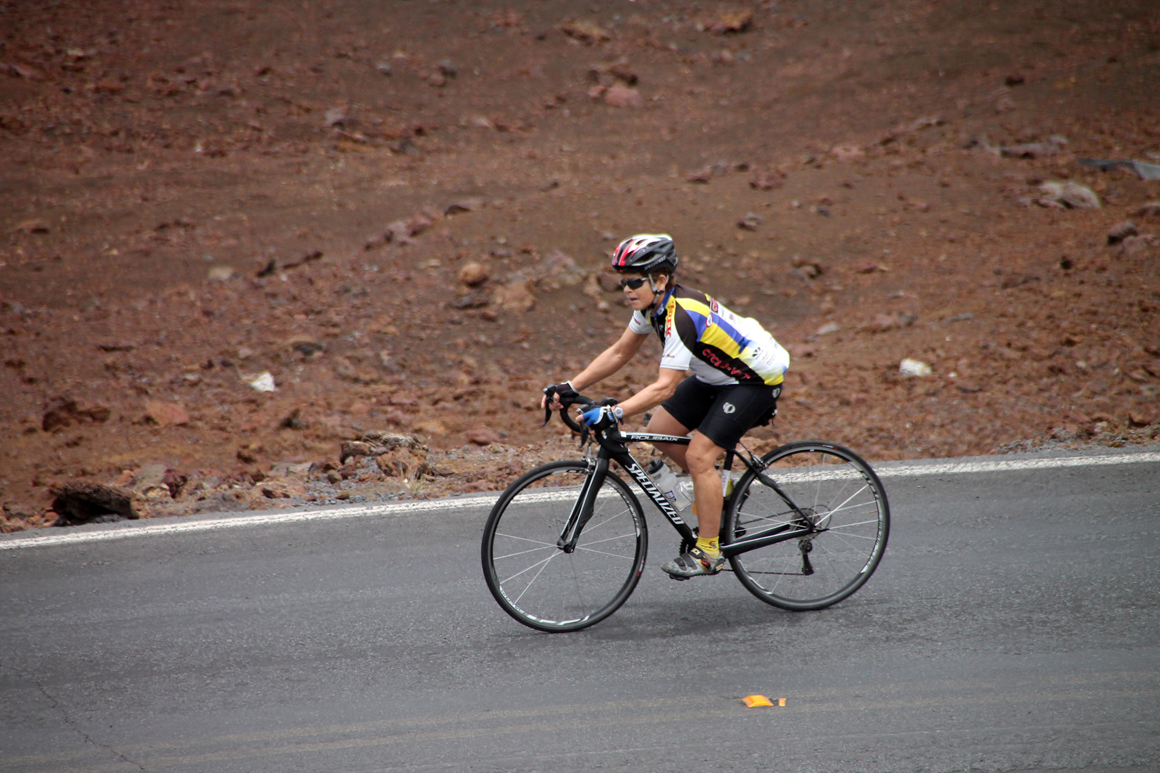
The views were spectacular. Here we are at 5,000 feet - halfway - yea!
Switchback after switchback, they just keep coming. about the 6000ft elevation mark, the road straightens and heads east for about two miles. At the beginning of the straight away, you actually get to shift into your big chain ring(if you choose to do so, another descent, YIPPEE). This section is where I usually notice the clouds start and it is often into the wind. At the end of this relatively straight section, you enter a heavily treed section(pine trees). After you wind through the pine trees(about 6500ft elevation) you will exit the trees and you will see the Haleakala National Park entrance sign on the right. Good photo Op.

6500 right in the middle of the rain line
Just ahead is the actual park entrance. Get that credit card ready for the $15.00 entrance fee.
In another half mile or so is the Haleakala Ranger station. There are restrooms and water fountains. This is your LAST stop for water that I know before the summit. You have about 12 miles and 3300ft of climbing left to reach your goal.

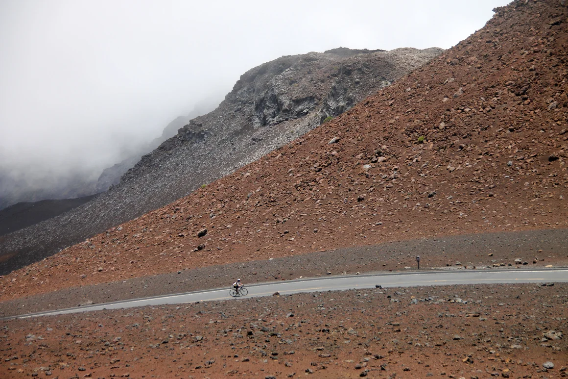
The road is narrow and kind of stark in nature. Any off road excursions planned or unplanned will end painfully. Next to the road is lava rock, Lava Rock and More LAVA ROCK.
This is where you have to dig deep into you mental fortitude. You have been climbing for hours and are over a mile above sea level. Unless your name is Ryder Hesjedal, our current record holder 2hrs 31min!
This is where I find myself mentally wandering. The pavement just in front of my tire tends to be my view. Get through this section! Just do it! Know your mileage or know your altitude. This helps me to get to the top. Not a lot of landmarks to aid for reference of where you are. Again, Mahalo to CTTS for painting those sayings and elevations on the pavement.

At this point, Ellen is feeling great knowing that "only" 1,000 feet of climbing remains.
From 9000ft elevation and a few miles to go you will be staring at the telescopes on the summit.
They look soooooo close. Not just yet. The road will begin to fade to the left as if to go away from the summit. Shoootz!!! Don't worry. it is just the final left turn to the lower parking lot. Did I say LOWER parking lot? Plenty of water and restrooms at the east end of this lot. You mean I'm not there? Not yet! Then you see your last two pitches. NASTY. Yes these are ASS kickers.

It's woman vs. volcano as Ellen nears the summit. Shortly after this photo, it became rainy and windy.
Make the right turn at the summit sign and begin your last two torturous climbs. Not long, but steep and IN YOUR FACE. Midway you make a hard right. Stay right. Left takes you down to the telescopes and not to your goal. You are almost there. Just a couple hundred yards and the parking lot is there.
Ellen is definitely working as she sees the 10,023-foot summit approaching just ahead.
At the far end of the lot you can access a sidewalk that leads up to the summit house. Your GOAL. There is a sign above the door of the summit house that reads "10,023ft. Take lots of pictures. YOU EARNED every one of them. Congratulations.
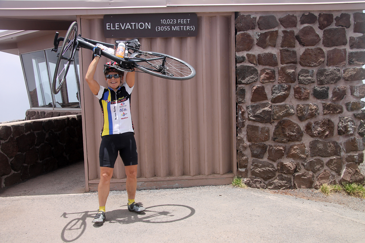
At the top - a wonderful feeling to finish a ride made in tribute to Doc West, a longtime friend.
Now you want me to get down. Can't i just lay here a while?
If you crack the 4 hour mark, you had a great day(unless you make a living racing bikes). Plan your day before you do this ride and be methodical. Don't blow up in the lower sections. Eat, hydrate and have a great experience. This is the longest, highest sustained road ride in the World. A really good rider (Tony L.) once told me how to ride the crater and survive it. I took his advice to heart and have been climbing the crater happily ever since.
This was his advice; Break the climb into unequal distance thirds. Paia to Kula, Kula to the Park entrance and the Park entrance to the summit. What ever time it takes you to do the first 13 miles to Kula, keep a pace to do the next 10 miles to the Park entrance then the same pace to do the next 13 miles to the summit. It has worked for me for many years. Tony was the first person that I had ever heard of doing the crater twice, that's back to back on the same day. Crazy, just Crazy. I take his advice, readily.
Below you will find a click through gallery of all the major points you will need to know about while climbing up to the sun. Click though to familiarize yourself with what to look for.


Riding down is definitely harder than riding up in my opinion. If you do decide to ride down, be careful, high speeds can be reached and off road excursions can lead to LAVA or trees. If it's wet, it is slippery; If it's foggy, it's really not fun. If you are physically and mentally spent, you might not be making good decisions on speed modulations. Just take care.
What more can I add? If you are not sure of riding the crater, just ask the staff of West Maui Cycles.
Aloha and have a safe crater ride.
Mahalo!
Scot at West Maui Cycles